2026 Tour de Blount
Date: Saturday, May 23, 2026
Location: Start/Finish at Crawford House on Maryville College Grounds
1. OVERVIEW
- The 2026 Tour de Blount will start and finish at the Crawford House on the Maryville College campus.
- Race start time is 07:30 AM.
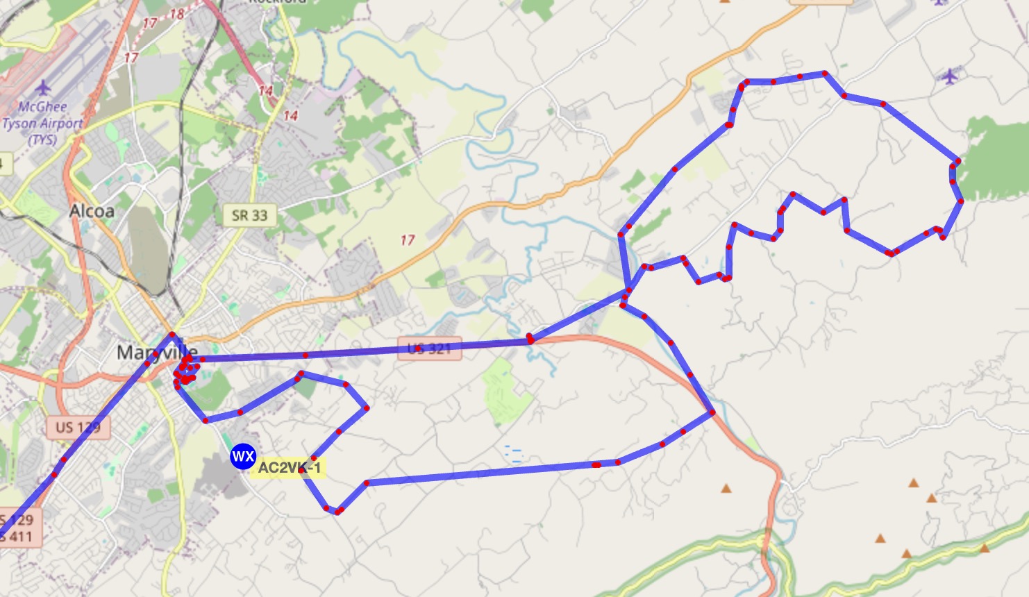
- The event includes 25 Mile, 50 Mile, and 75 Mile routes utilizing local roads across Blount County.
- Primary communications goals are rider safety and coordination of transport for riders with equipment breakdowns.
- Lunch will be provided for all active volunteers and riders.
- Route is the same as last year.
- No weapons are allowed on the Maryville College campus.
2. OUR ROLE
Provide reliable, real-time communications coverage along the race routes in order to:
- Relay status updates from race personnel,
- Report medical or logistical issues to race personnel,
- Monitor safety conditions along the course,
- Assist in coordination of race logistics,
- Coordinate SAG support and rider assistance.
Operators should arrive at the start/finish area by 07:15 unless proceeding directly to their assignment location.
3. EXECUTION
a. Concept of Operations
- Net Control and communications trailer will be established near the Crawford House.
- NCS trailer setup begins Friday evening.
- Communications volunteers may either report to the start/finish area or proceed directly to assigned positions.
- Check in with NCS upon arrival at your assignment.
- Tactical call signs will be used, followed by FCC call signs at the end of each exchange.
- Keep transmissions brief and concise.
- Do not report rider names or injury details over the air.
- Request NCS contact 911 if emergency services are needed.
b. Timeline
| Time | Activity |
|---|---|
| 06:45 AM | NCS and trailer setup begins |
| 07:15 AM | SAG operators arrive at start |
| 07:30 AM | Race start / Net active |
| 07:45 AM | WS1 operational |
| 08:00 AM | WS2 operational |
| 08:15 AM | WS3 and WS4 operational |
| ~02:00 PM | Event concludes |
c. Assignments
Net Control and Support
| Tactical | Callsign | Name | Notes |
|---|---|---|---|
| NCS 1 | AI4SI | Rick | Trailer setup and operations |
| NCS 2 | W7FKI | Jim | Trailer setup and operations |
| Support | N9KMY | David | Assist setup and teardown |
| KI4HDU | William | APRS setup support |
Water Stops
| Tactical | Location | Callsign | Name | Onsite |
|---|---|---|---|---|
| Hillcrest Baptist Church | ||||
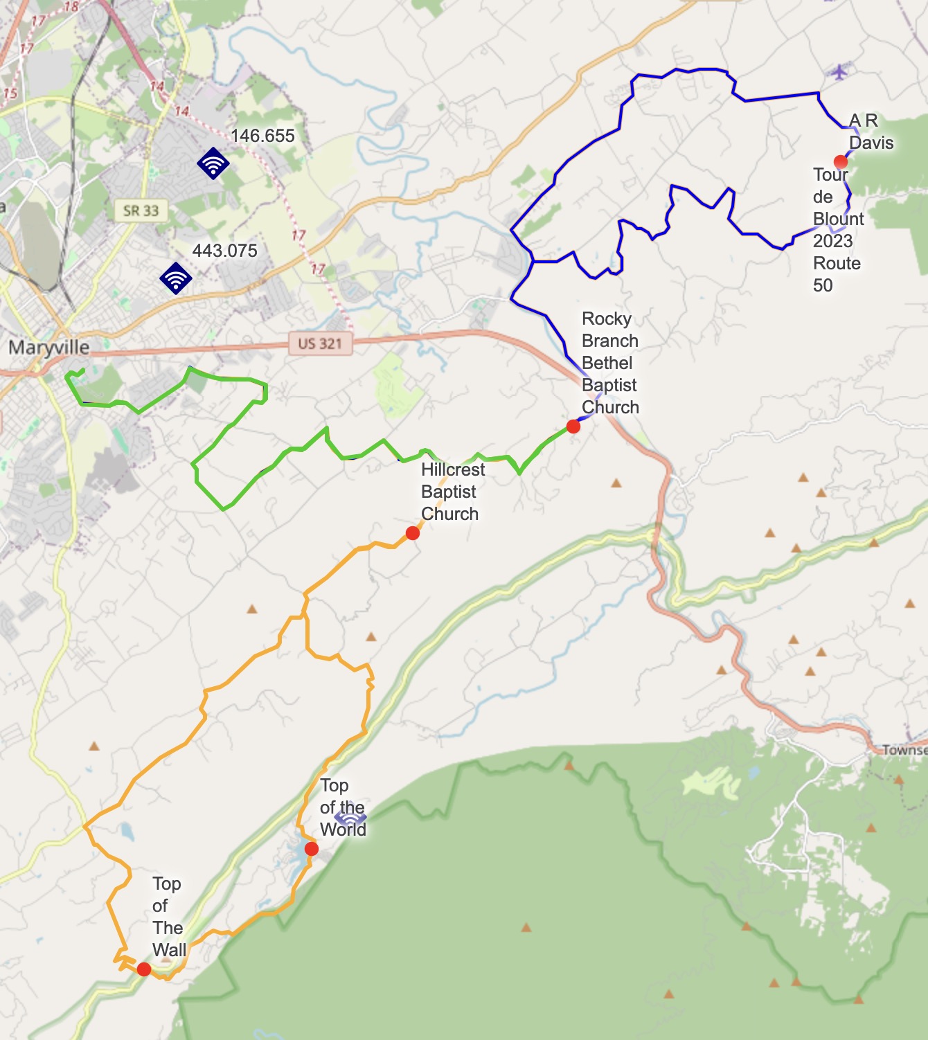
| WS1 | Rocky Branch Bethel Baptist Church – 4502 Rocky Branch Rd | AA0JE / KK4MG | Jim / Mike | 07:45 |
| WS2 | AR Davis Rd – private drive 2.3 miles from Ellejoy Rd | W4NFN | Ramsey | 08:00 |
| WS3 | The Wall – last turn before tunnel on Happy Valley Rd | NW1A | Craig | 08:15 |
| WS4 | Top of the World – Flats Rd, 2.3 mi east of Happy Valley Rd | KD4VLH | Chuck | 08:15 |
Do not park inside the tunnel at WS3.
SAG Assignments
| Tactical | Callsign | Name | Route |
|---|---|---|---|
| SAG1 | KE4FGW | David | 75 Mile |
| SAG2 | KI4HDU | William | 75 Mile |
| SAG3 | WB3JKQ | Lou | 50 Mile |
| SAG4 | WB5KSM | Melvin | 50 Mile |
d. SAG Operations
- SAG vehicles must be capable of transporting both rider and bicycle.
- APRS tracking is strongly encouraged.
- Carry basic tools, tire pump/adapters, extra water, warning sign, and flashing light.
- SAG1 or SAG2 will precede the race start and stage at WS1.
- One SAG should support the lead group while another supports trailing riders as the field spreads out.
- Tail SAG may advance to water stops after counting riders behind them.
- Maintain approximately 200 feet following distance behind riders.
- Pass cyclists only when safe and maintain at least 3 feet clearance.
- If traffic backs up behind your vehicle, pull over safely when possible to allow vehicles to pass.
4. SERVICE & SUPPORT
- Please wear your Blount County ARES shirt.
- Bring radios, extra batteries, larger HT antennas if applicable, and personal supplies.
- APRS frequency: 144.390 MHz.
- Bike support shop will be located beyond Bethel Baptist Church.
- Route cue sheets and GPX files are available on the BCARES Team App.
- Prepare for possible rain conditions.
5. COMMAND & SIGNAL
a. Net Control
- AI4SI and W7FKI will serve as Net Control Stations and coordinate all radio traffic.
- NCS will monitor both primary and backup repeaters throughout the event.
b. Frequency Plan
| Purpose | Frequency |
|---|---|
| Primary Repeater | 146.625 MHz (-) TSQL 118.8 |
| Backup Repeater | 146.655 MHz (-) TSQL 100.0 |
| APRS | 144.390 MHz |
| Trailer/Crawford House Simplex | 146.550 MHz |
| APRS Digipeater | W4ETR operational at repeater site |
c. Reporting
- Check in with NCS upon arrival at assignment.
- Keep transmissions short and professional.
- Report hazards, rider support requests, and logistical issues.
- Do not report rider names or medical details over the air.
- Clear with NCS before leaving your assignment.
Have fun, be safe, and thank you for supporting this important event.
After Action Notes
Timeline
- 5:51am : Leaving home. Beginning mileage 117,931.8 #mobile
- 6:47am : Arrive Maryville College. Mileage 117,964.5 #mobile
- 7:42am : On the course #mobile
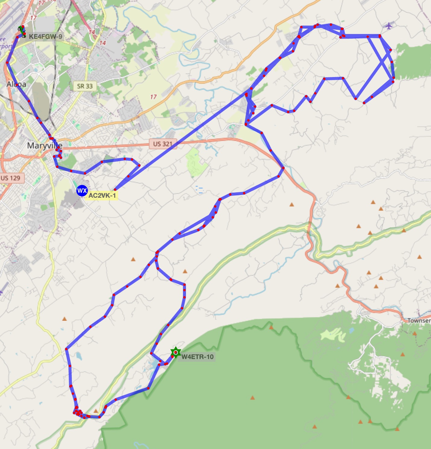
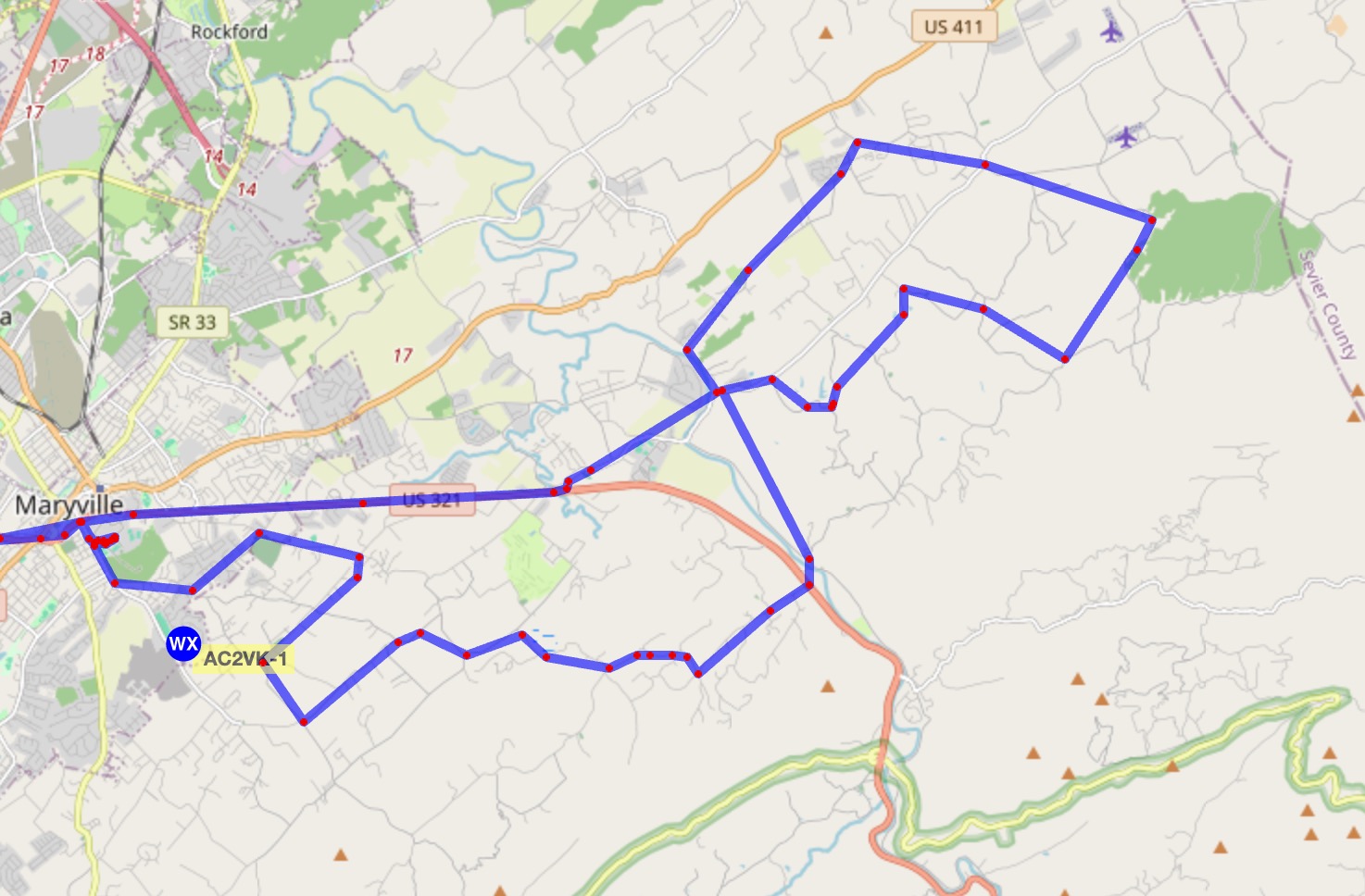
- 9:06am : Lead rider encountered coming down from top of the world number 64 @location(35.66177529729426, -83.90841274712274) #mobile
- 9:53am : Following the course, leaving WS3 #mobile
- 11:09am : At Coulters Bridge
- 12:25pm : Hauling one rider back due to cramping #mobile
- 12:41pm : Lunch #mobile
- 3:05pm : Back home, ending mileage 118,066.6 #mobile
Event Narrative
There were only about 150 riders - 25 of which took the long route; I'm not sure how the two smaller routes broke down.
The rain held off until around 10am - allowing everyone to make it to the top of the world rest stop before the rain moved in. After the initial down-pour, it was spotty for the duration of the event. We hauled a few people in after the rain started, but not a significant number (less than 5 total I think).
I did not hear of any mechanical issues nor did I hear about any wrecks or other traffic issues.
The markings for the left turn onto Flatts road was much improved this year - leading up to the turn they added a number of blue arrows mounted on traffic cones that would have been very hard to miss. Someone thought it would be a good idea to steal the signs on the eastern portion of the route - the race directory was not happy about that, but in addition to the signs, they had painted the road and I did not hear about anyone getting lost.
The "rest stop" at Hillcrest Baptist Church was not manned beyond us having Chuck there. At least one rider was picked up here and hauled back in (private SAG).
The rest stop at Top of the World was NOT set up at all - the folks who run that area said it was booked for an event and did not allow it; as you can imagine the race director was not happy about that. I'll note that when I was there shortly after 9, then again shortly after 10am, the lot was empty.
Jim and Mike were at the Rocky Branch church rest stop - as far as I know things went pretty smoothly there.
Ramsey was at the rest stop on AR Davis - again, that one seemed to work smoothly - it had the same event volunteer that has been there for a couple of years.
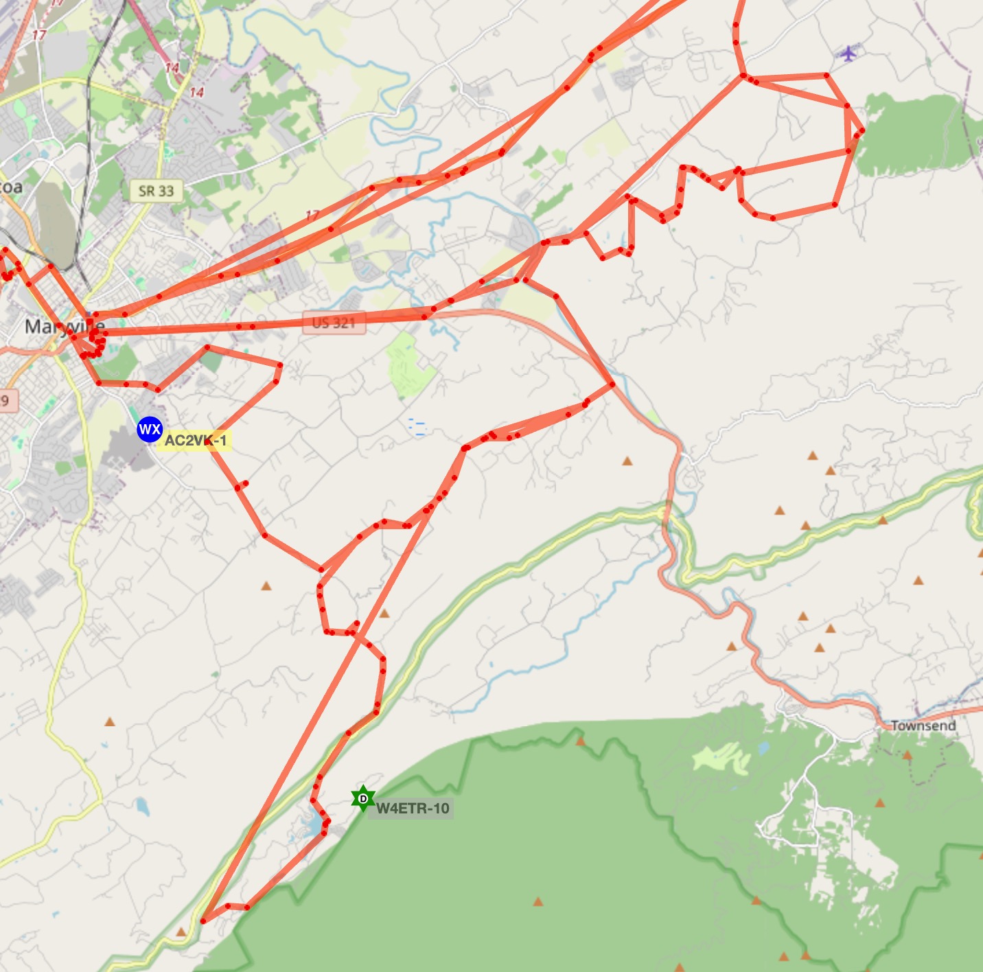
David, KE4FGW, and I were the SAGs on the long route. David staged at Hillcrest Baptist Church. I was at the college until after all of the riders left, so I started at the very end. I caught up to the tail of the event (with a large group of riders) and Melvin around mile 6 and Lou was coming behind me, so instead of having a convoy of SAG vehicles, I went off-course to the rest stop on Laws Chappel (staying on Wilkinson Pike to Laws Chappel). At that rest stop, I met up with David - he proceeded on the course and I went the opposite direction to the rest stop at Rocky Branch Bethel Baptist Church. I left that rest stop and proceeded backward on the 72 mile (turning on Butterfly Gap) knowing that if I followed the riders I would simply come up behind David. I encountered riders coming down from Top of the World about 3 miles about 2 miles down from TOW. I met David a little further up the road - he continued on-course behind the riders (about 1/2 of the pack was ahead of him) and I continued back to the rest stop at the tunnel. I waited at the tunnel for the last rider (the race director had done a sweep up from the bottom and confirmed the last rider). Once the last rider passed, the race director and Craig (who had been working that rest area) went backward on the course in case we missed someone. I turned around and followed the last rider down the mountain.
Back at Hillcrest, there was a rider having cramping issues...he stretched for a bit, then said he was going to push on. I did the typical leap-frog thing with him all the way to the rest stop at AR Davis.
As I approached Coulter Bridge, I noticed that David had nearly completed the eastern loop and I would pass him shortly, but when he reached Ellejoy, he turned around and covered the course backward. We met at the AR Davis rest stop. After giving my rider some time, I went back to check on him...he decided he was done and wanted a ride. David proceeded along the course sweeping, I hauled the rider back to MC.
I lost track of what Lou and Melvin were doing - I know they hauled some people in, but I'm not sure how many people.
Repeater coverage was good over the entire course.
APRS performed reasonably well. Something happened to W4BBB-1; it has been off-air since 2026-05-23 at 4:34am, so our only digi was W4ETR-10. Lou had some power issues with his radio that caused some gaps in his transmissions, but coverage overall seemed good. About 1/2 way into the course, I started running APRS on my tablet adding -5 to the mix...having two stations for me on the air at the same time proved to be confusing and a lesson learned for me - in the future, that station will be receive only.
Lou:
Me:
Melvin:
David: